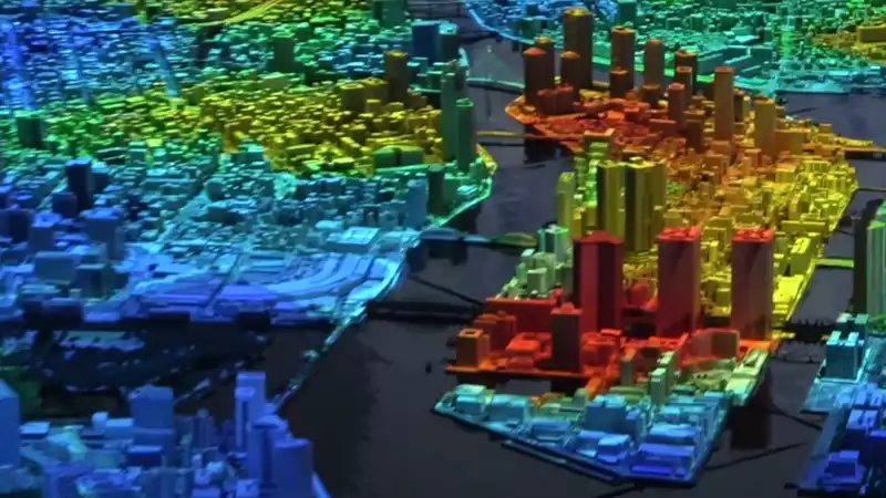
This sprawling urban lab project (via TechExplore) at the Mori Building in Tokyo is a permanent 1:1,000 scale model of Tokyo that is constantly changing, overlaid with augmented reality (AR) layers. It is essentially an overlay of Cities: Cities:Skylines."
You want to go check out professional traffic management ideas like ring roads and roundabouts, but this is more than just displaying road layouts and tourists taking pictures of mini Tokyo Towers.
The AR projection mapping feature of this diorama, along with the synchronized background display, provides more than just highway and rail intersections. It includes an overview of business and population density, and even a timeline of how the coastline has changed over the years.
Through a combination of various overlays, this interactive diorama tells researchers and developers in detail which areas are most prone to flooding, among other potentially avoidable natural disasters. By visualizing data in this way, they can get a better idea of where and how development should take place and plan to minimize the impact of such incidents.
The 78-foot model, first unveiled in 2019, covers 13 of the 23 districts (143 square miles) that make up the city of Tokyo and is displayed alongside a scale model of New York City for reference. Each year, these installations grow and change with the cities they represent, becoming living models. Each year, as these cities adapt, new photographs of urban development are studied and designers gather with Styrofoam and scalpels to update the models.
Projects like these feed urban development programs, arming them with knowledge that will not only contribute to more efficient cities of the future, but also save lives. As we move toward a future that relies on high technology, we can look forward to more great projects like this one.
Comments